


The Entrance


103kms · 95 mins by car
63kms · 70 mins by car
4,244 population (2021 Census)
The Entrance is a popular holiday resort offering visitors surfing beaches, enormous lake recreational areas, and a central area with attractive foreshore parkland, a Boardwalk pathway from the foreshore around to the surf lifesaving club, and the development of a family-friendly open-air mall called The Waterfront.
Attractions
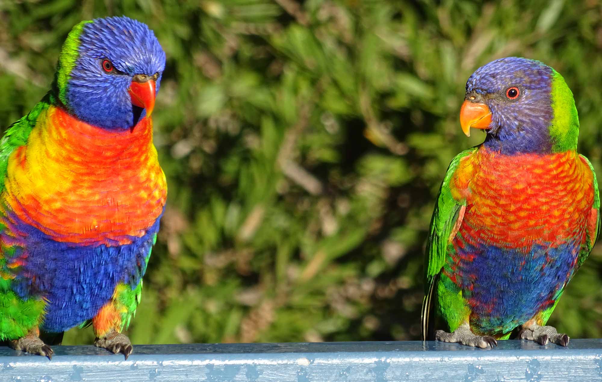
 One of the Central Coast's most popular family friendly experiences is Pelican Time at The Entrance Saturday and Sunday 3.30pm, and everyday in the School Holidays (Except Christmas Day). See these huge birds up close and fully appreciate their beauty and size! The hardworking volunteers from Marine Wildlife Rescue will share their valuable knowledge on all things pelicans, as well as fascinating information on other wildlife in the region.
The Boardwalk follows the channel eastwards from Memorial Park around to the surf lifesaving club. It starts at The Waterfront, a popular mall with cafes, eateries and fountains designed for the amusement of children. In the school holidays, the mall takes on a carnival atmosphere at The Waterfront.
A Bike Path strectches from the Skate Park at The Entrance to Chittaway Point around the spectacular Tuggerah Lake. This ride is ideal for the whole family with many rest points and parks along the way including playgrounds and picnic areas.
At the north-western corner of the southern peninsula is Picnic Point where there is a popular family oriented park and a boat ramp. Just offshore lies Pelican Island, a breeding site for migratory wading birds.
The Entrance War Library Museum on The Entrance Rd near Tuggerah Lakes Memorial Club has memorabilia dating back to the Crimean War.

Lions Club Market (behind Cinema in Car Park) Sundays 8am-12noon.
Nearby, on the south-western side of the southern peninsula is Long Jetty the base of sailing on Tuggerah Lake with The Long Jetty Sailing Club at the northern end of Tuggerah Parade.
A number of bays and rocky headlands, Blue Bay, Toowoon Bay, Little Bay, Shelly Beach (a major surf beach) and Bateau Bay, can be accessed south along the southern peninsula. The very pleasant Swadling Park is at Toowoon Point which divides, and provides good views over Little Bay and Toowoon Bay.
Wyrrabalong National Park covers 597ha but is divided into two distinct and separate sections. Wyrrabalong, meaning 'headland looking over the sea' is a word of the Darkinjung people who once occupied the narrow strip of coastline between Bateau Bay and Forresters Beach.
The southern section is characterised by high, exposed coastal cliffs of sandstone and shale which have extensive rock platforms at either end. Woodlands of blackbutt, spotted gum and bloodwood stand along the plateau, with shrubs and heath (mostly coastal banksia and she-oak) on the gentler slopes to the west. The area at the southern end of Bateau Bay is home to a diverse range of marine and bird life, mangrove stands and fauna including goannas, bandicoots, fantails and the tawny frogmouth.
Crackneck Lookout (274m high) beyond the southern end of Reserve Drive offers spectacular views. Nearby, Reserve Drive runs alongside a strip of parkland that overlooks the beautiful Bateau Bay.
 Wyrrabalong Lookout, further south on Cromarty Hill has an adjacent concrete platform with views to the south and west. A short path leads to Wyrrabalong Lookout on the cliff's edge, 132m above sea-level with panoramic views south to Terrigal.
A 3.8 km walking track starts on the eastern side of Bateau Bay Rd at Blue Lagoon, finishing at Wyrrabalong Lookout.
The park's northern section covers most of the North Entrance Peninsula starting at the tip of North Entrance and ending at Pelican Point south of Noraville. The diversity of fauna and flora includes the lace monitor, flying fox, bandicoot, squirrel glider, diamond python, possum, New Holland Mouse, antechinus and many birds.
The ocean side is mostly coastal dunes with beach access via Pelican Beach Rd (at the northern end) and the Tuggerah Beach Walking Track (700m) leading to popular but unpatrolled surfing and fishing areas.
On the western side of the road there is a strip of red gum forest with remnants of littoral rainforest and some open scrubland and wetlands. The wetlands trail extends northwards to viewing platforms at the rim of the main sand dune.
Anglers will find the area good for flathead, whiting, bream, blackfish and prawns. The sea-wall adjoining the boatshed near the bridge is a good spot for blackfish. Surf fishing from November to April yields jewfish, whiting and tailor.
Tuggerah Lake is also ideal for anglers. Blackfish, whiting, mullet, snapper, bream, flounder, tailor, flathead, jewfish, tarwhine and crabs can all be caught from the foreshores. Prawns are usually plentiful in mid-summer and can be snared at night with a lamp and net by wading into the shallows.
The lake is the principal coastal lagoon of an interconnected 80 sq km lake system with a narrow channel separating it from Budgewoi Lake at its northern tip which is joined at its north-eastern corner to Lake Munmorah.
The three lagoons are ideal for waterskiing, canoeing, sailing, rowing and sailboarding and are separated from the Pacific Ocean by long, narrow peninsulas. They share common access to the ocean at The Entrance.
 History
The lakes and foreshores were cleaned up and restored in the late 1980s.
Interest in the area began in 1796 when shipwrecked fishermen landed on the coast. They were fed by the local Indigenous Australians who guided them most of the way home. When they returned to Sydney they told of a white woman living amongst the indigenous peoples and this resulted in an excursion to find the woman. The search party became the first Europeans to discover Tuggerah Lake.
The first European settler was Henry Holden who selected 260ha at Picnic Point in 1828. Chinese fishermen established a base in the late 1820s at what is now Toowoon Bay (still known to some as Chinamans Bay). They cured and smoked their fish there, and sent them to Queensland, China and the goldfields.
Tourism started with the completion of the rail line from Sydney to Newcastle in 1889. Visitors from Sydney travelled by launch from the train station at Wyong or direct from Sydney by seaboat, to fish, swim and walk in the area. A holiday camp was established at Toowoon Bay in the early 1890s and the first guesthouse in the area opened at North Entrance in 1895.
The first school opened in 1915 and the first church was built in 1926. Growth remained slow until the 1920s but The Entrance inevitably became a popular tourist spot for people drawn by the fishing and beaches. The first bridge linking the two sides of the channel was erected in 1934. The Entrance became a popular tourist destination after the freeway was built in the 1960s.
Known by a number of names over the years - Toowoon Bay, Tuggerah Beach, Karagi (the Aboriginal name for the channel) - the settlement around the channel became The Entrance when the post office opened under that name in 1911.
The Entrance name comes from the narrow channel that divides the mainland and connects Tuggerah Lake to the ocean.

See also:
- Avoca Beach
- Bateau Bay
- Brooklyn
- Budgewoi
- Cams Wharf
- Canton Beach
- Catherine Hill Bay
- Copacabana
- Erina
- Ettalong Beach
- Forresters Beach
- Gosford
- Hardys Bay
- Killcare
- Kincumber
- Lake Macquarie
- Long Jetty
- Norah Head
- Patonga
- Pearl Beach
- Shelly Beach
- Terrigal
- The Entrance
- Toukley
- Tuggerah
- Umina
- Wagstaffe
- Woy Woy
- Wyong
- Local Town Guide Home
- Visitor Information Home


Central Coast Australia Social Pages